Above-average temps nearing records this week. How are those records tracked?
You've heard it in almost every nightly forecast: Temperatures are "above average," "below average" or near "average." But what does it mean?
More Stories


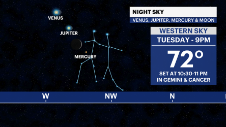


You've heard it in almost every nightly forecast: Temperatures are "above average," "below average" or near "average." But what does it mean?
Records for Central Park go back more than 150 years to 1869. In that time, things have changed a lot.
The climate average is actually based on the past 30 years of data, because that most closely represents the weather we experience today.
The current period of time is from 1990 to 2020. It's a rolling average, so at the end of this decade, the average conditions will shift again to reflect data between 2000 and 2030.
MORE: Summer in October? Tri-state sees rare trend of 80-degree temps near Halloween
During transition seasons, it's expected that temperatures will stray from the average from time to time. The average high is near 60 in late October for New York City, but temperatures 3 degrees in either direction are still considered normal for this time of the year. What's not normal is breaking records that go back more than 100 years.
Record high and low temperatures take into account all the data that we have for the city into the 1860s. In recent years, record-high temperatures are becoming much more common than record lows. Although it's true, every now and again the city will set a new record-low temperature - it's at a much lower rate than record highs. Since 2020 the city has set seven new daily record-high temperatures and no daily record lows. It's a trend we're seeing more frequently since the 1990s in New York and other climates across the world.