STORM WATCH: Warmer weather arrives; tracking thunderstorms midweek
A stalled front will bring showers and scattered thunderstorms Wednesday and Thursday.
News 12 Staff
•
May 6, 2024, 10:06 AM
•
Updated 12 days ago
Share:
More Stories
2:06

Mild and dry Sunday in New York City
5h ago1:41

Warmer and stormier weather arrives Tuesday for NYC
5ds ago1:41

Thursday night rain carries over and sticks around through Friday
9ds ago1:02

Bright news: Here come the longer days and later sunsets
10ds ago1:28
Brooklyn residents enjoy beautiful day at Coney Island boardwalk
20ds ago1:41

STORM WATCH: Chilly morning temperatures with light scattered showers Thursday
45ds ago2:06
Mild and dry Sunday in New York City
5h ago1:41
Warmer and stormier weather arrives Tuesday for NYC
5ds ago1:41
Thursday night rain carries over and sticks around through Friday
9ds ago1:02
Bright news: Here come the longer days and later sunsets
10ds ago1:28
Brooklyn residents enjoy beautiful day at Coney Island boardwalk
20ds ago1:41
STORM WATCH: Chilly morning temperatures with light scattered showers Thursday
45ds agoNews 12 Storm Watch Team Meteorologist Allan Nosoff says rain will likely arrive late on Tuesday and scattered thunderstorms will be on the menu for Wednesday.

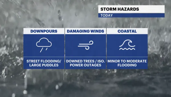
NEXT: It turns unsettled this week with a chance of showers/storms through this weekend. Temperatures will be in the 60s to the 80s. A stalled front will bring showers and scattered thunderstorms Wednesday and Thursday. There is an isolated risk of strong to severe storms on Wednesday.
Catch the Brooklyn forecast below:
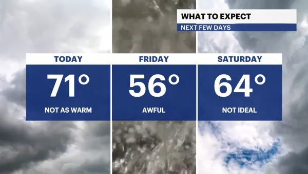
TONIGHT: Mostly cloudy and warmer. Lows only down to 60.

TOMORROW: Sunny and warm! Highs jump to 81 away from the water (70s near/along water). Lows near 62.

WEDNESDAY - STORM WATCH: A morning round of showers and t-storms, most likely between 5 and 10AM. One or two storms may be severe, but low-end. This timing is subject to change. Then sunny and even warmer. Highs jump to 84 away from the water. Lows down to 59.


THURSDAY - STORM WATCH: Cloudy and much cooler. T-storms likely between noon and 6PM. This timing is subject to change. These storms may be severe, and more impactful than Wednesday's. Highs near 66. Lows down to 51.

MOTHER'S DAY WEEKEND: Cool and mostly cloudy. There is a chance of showers on Sunday but too soon for details. Highs in the 60s. Lows near 50.